



TALLAHASSEE, Fla. (WTXL) — Update
July 22nd 4:00 p.m.
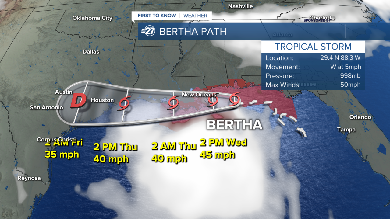
Tropical Storm Bertha's center of low pressure crossed over land in southeastern Louisiana Wednesday afternoon, with highest winds of 45 mph and the bulk of its heavy rain staying offshore in the Gulf waters.
Locally, passing showers along the Apalachicola River counties are one remaining side effect from the southerly flow around Bertha. Winds and these showers will further decrease over the next several hours. No leftover effects directly caused by Bertha are forecast for Thursday.
Update
July 22nd 5:00 A.M.
Tropical Storm Bertha is heading directly west toward New Orleans at 5 mph. It is currently about 70 miles south of Mobile, Alabama. The peak winds have weakened to 50 mph.
Locally, there will be a few scattered downpours along our western edge, cut off around Tallahassee. Wind gusts can still peak around 30 mph for our area.
Update
July 21st 11:30 P.M.
Tropical Storm Bertha continues on its path generally toward the west. Its center is about 100 miles south-southeast of Mobile, Ala., with highest winds of 60 mph around it. It's moving west at 6 mph.
Locally, passing downpours will affect a few neighborhoods from time to time Wednesday, with a greater focus on the western Big Bend and southwestern Georgia. Severe weather is not anticipated but heavy rain can come with some briefly strong wind gusts.
Breezes will be occasionally stiff at the coast but will gradually relax through late Wednesday.
Update
July 21st 11 A.M.
Tropical Storm Bertha has gained more strength and its wind are peaking at 60 mph. It had gained speed moving northwestward at 5 mph, but as of the latest update it has slowed to 3 mph.
Bands of rain continue to peel off the storm and flow into our area. These will become fewer, and more scattered as the day progresses. The wind gusts can still peak at 40-50 mph along our coast. In fact at 8:13 A.M. a weatherstem site reported 41 mph wind gusts in Horseshoe beach. Another site in Saint Marks reported 46 mph wind gusts at 7:59 A.M.
No new watches, warnings, or advisories have been issued for our area. A Tropical Storm Warning has been issued for our neighbors in Panama City Beach.
Update
July 21st 5 A.M.
Tropical Storm Bertha has gained more strength and now has peak winds of 50 mph. It is still moving nearly stationary at only 2 mph northwestward.
Bands of rain throughout the day and gusts around 35 mph outside of the coastline will be our main concern. Winds along the coastline can reach 40-50 mph.
Our coast is no longer in a Tropical Storm Watch, but we are in a Wind Advisory and Marine Warning. Wave heights and strong rip currents are our main concern along our coastal waters.
Original
July 20th 8 P.M.
Tropical Storm Bertha developed from the raggedly formed mass of clouds and rain swirling in the northeastern Gulf of America / Gulf of Mexico Monday evening as its core stays southwest of the Big Bend region.
The tropical storm has peak winds of 40 mph and its movement late Monday night was nearly stationary.
A tropical storm watch remains in place for areas from Apalachicola westward. This means occasional wind gusts of 40 mph are possible within the watch zone in the next 48 hours.
Tropical Storm watches and warnings have been discontinued for Apalachee Bay and coastal Franklin County.
As the system is set to remain over the waters of the Gulf in the days ahead, the expectation is for the storm to move west to northwest, essentially parallelling the Big Bend and Panhandle coastlines. This would keep the center of the system offshore.
Bands of rain, showers, and thunderstorms can be experienced along the coastal areas and just inland from there through Tuesday. Rainfall can be heavy at times, with a low risk for flash flooding and excessive rainfall particularly along the coast, where isolated rain totals have already exceeded two inches.
Isolated thunderstorms have the chance to become briefly severe, mainly along the immediate coast and offshore.
Water levels along the central and western Big Bend coast may be as high as three feet above normal levels Tuesday, an increase caused by the onshore wind flow.
While local winds can gust upwards of 25 mph, broader adverse effects from sustained wind are not anticipated locally. However, to account for occasional gusts near 40 mph at the immediate coast, a wind advisory will be in effect in coastal Franklin and Wakulla counties Tuesday.
Want to see more local news? Visit the WTXL ABC 27 Website.
Stay in touch with us anywhere, anytime.
