

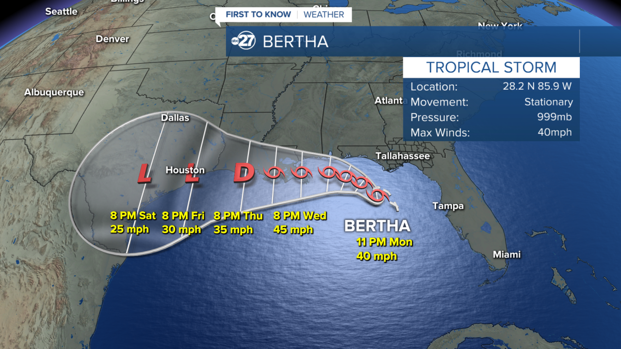


TALLAHASSEE, Fla. (WTXL) — Update
July 20; 5 P.M.
Tropical Depression Two remains poorly developed late Monday afternoon as it is continuing to move northwest at 3 mph. Maximum sustained winds have held steady at 35 mph.
Drier air within the circulation and swift upper-level winds coming in from the north have hindered the tropical depression's development efforts.
Occasions of showers and rain will continue to stream in periodically from the bay waters. Isolated gustier storms can affect the immediate coast this evening, with a few more rounds of showers and storms through Tuesday.
Local breezes will not be extraordinarily strong, but some gusts upwards of 30 mph can be experienced along the coastline.
A tropical storm watch remains in place for coastal Franklin County and the adjacent waters out 20 nautical miles.
Update
July 20; 5 A.M.
Tropical Depression Two is continuing to move north/northwest at 3 mph. Maximum sustained winds have strengthened to 35 mph.
Tropical storm development is expected by this afternoon, becoming Tropical Storm Bertha around 2 P.M. The biggest impacts will be felt around the coastline with wind gusts reaching potentially 40-45 mph, and sustained winds around 35mph. Wave heights can reach 3ft, along with consistent rain and storms.
No new watches or warnings have been issued locally.
Update
July 19; 11 p.m.
Tropical Depression Two has began its trek towards the north/northwest at 3 mph. Maximum sustained winds remain at 30 mph.
As the movement continues into Monday, a tropical storm formation is possible. However, regardless of development, local impacts remain the same as we would still be getting in on the outer rain bands throughout Monday and Tuesday.
No new watches or warnings have been issued locally.
July 19; 8 p.m.
Tropical Depression Two remains stationary in the eastern Gulf with maximum sustained winds at 30 mph.
Slow movement is expected overnight and early Monday morning as it makes a turn towards the west.
A Tropical Storm is still expected to develop sometime Monday. If development occurs, Bertha would be the name.
No new watches and warnings have been issued.
July 19; 5 p.m.
As of 5 p.m., Tropical Depression Two is currently stationary over the eastern Gulf. Maximum sustained winds remain at 30 mph.
The system is still expected to strengthen to a tropical storm Monday as it crawls towards the northwest.
Local impacts remain the same.
July 19; 2 p.m.
Tropical Depression Two continues to track north-northwest, but has slowed down to just 1 mph. Maximum sustained winds remain at 30 mph.
The very outer rain bands are starting to move onshore along the Big Bend coast and will continue to do so throughout the evening. Showers will make their way inland across the Big Bend slowly.
No changes to watches and warnings at this time.
Original
July 19; 11 a.m.
Tropical Depression Two has formed in the eastern Gulf of America / Gulf of Mexico, south of the Big Bend region.
The raggedly formed depression has peak winds of 30 mph and is moving north-northwest at 2 mph.
A tropical storm watch is in effect for areas from the mouth of the Ochlockonee River westward. This includes the Forgotten Coast region of the western Big Bend. This means occasional wind gusts of 40 mph are possible within the watch zone in the next 48 hours.
Tropical Storm warnings are in place for waters of Apalachee Bay beyond 20 nautical miles from the coast.
As the system is set to remain over the waters of the Gulf in the days ahead, the expectation is for the depression to move west to northwest, essentially parallelling the Big Bend and Panhandle coastlines. This would keep the center of the system offshore.
Bands of rain, showers, and thunderstorms can be experienced along the coastal areas and just inland from there through early this week. Rainfall can be heavy at times, with a low risk for flash flooding and excessive rainfall.
Isolated thunderstorms have the chance to become briefly severe, particularly along the immediate coast.
Broader adverse effects from wind are not anticipated locally.
Want to see more local news? Visit the WTXL ABC 27 Website.
Stay in touch with us anywhere, anytime.
