


UPDATE
Jan 18; 6 a.m.:
The Winter Weather Advisory and the Winter Storm Warning remain until 12 PM this afternoon. Snowfall totals in the Winter Storm Warning areas can be around 1-2" of wet snow and slush with isolated areas seeing 3". This will be focused along grassy areas, but travel can still be impacted.
The Winter Weather Advisory areas will still have less impacts, but can see some wintry mixture. A coating is possible off roadways. The timing is now pushed to 7-11 a.m. as the system pushes on around 12 p.m.
A hard freeze overnight tonight can create isolated ice and slick spots on roadways to start Monday morning. What does not evaporate can freeze over.
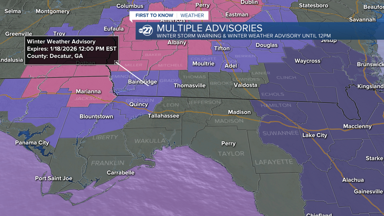
Jan 18; 12:30 a.m.:
The Winter Weather Advisory has been extended to include Grady, Gadsden, and north Liberty counties. The time remains from 4 a.m. - noon Sunday with up to 1" of wet snow expected.
A Winter Storm Warning is now in effect for Jackson, Miller, Baker, and Mitchell counties as snow is expected to accumulate to 1-2" with isolated spots possibly seeing 3".
Even though snow is expected, impacts remain low for those in the Winter Weather Advisory. Those in the Winter Storm Warning could see slight snow build up on roads and reduced visibility as the snow is falling, however, these impacts are expected to only last for a 1-3 hour period anytime between 5-11 a.m..
Jan 17; 11 p.m.:
We are continuing to see indications of winter weather Sunday morning. Accumulation models have decreased, but the chance for a dusting is still there for southwestern Georgia counties and mixed precipitation for Big Bend neighborhoods north of I-10.
Overall, still expecting minimal impacts for a few reasons.
1. We reached the 60s Saturday so the ground will not have enough time to cool and stay cool for any snow to stick.
2. Temperatures will reach the 40s by 10-11 a.m. and the mid 40s by the afternoon Sunday, melting any snow that falls.
3. Sunshine will prevail Sunday afternoon, another source that will melt any snowfall.
Jan. 17; 4 p.m.:
Chances continue to increase for winter weather mainly in southwestern Georgia counties including Jackson, Seminole, Decatur, Baker, and Mitchell. There is a 1-3 hour period between 5 a.m. and 10 a.m. Sunday morning for rain/snow mix or full switch to snow. Mixed precipitation is possible just south of the snow in Liberty, Gadsden, Leon, Thomas, Jefferson, and Brooks counties. These are the possibilities as of right now, but as this continues to be a changing forecast, we will keep you updated.
This is not expected to have major impacts as any snow that falls will either melt on impact or melt shortly after due to temperatures warming and sunshine following the precipitation. Snowfall accumulation, if any, will only be seen on grassy surfaces or elevated surfaces like roofs or trees.
Jan. 17; 12:30 p.m.:
The Winter Weather Advisory has been extended and now includes Miller, Baker, Seminole, Decatur, Colquitt, Cook, and Berrien counties.
Jan. 17; 9 a.m.:
A Winter Weather Advisory is now in effect for Miller and Baker counties starting at 4 a.m. Sunday morning and lasting until noon as a trace to one inch of snow is expected.
Overnight, confidence for winter weather has increased as the cold air is moving faster and models are starting to become more consistent, leaning in the direction of snow mainly for northwestern counties. Snow probabilities have now increased to 50-60% for Miller and Baker counties, 40-50% for portions of Seminole, Decatur, Grady, Thomas, Brooks, Lowndes, and Lanier counties, 30-40% for portions of Liberty, Gadsden, Jefferson and Leon counties, and 20-30% for portions of Wakulla, Madison, and Taylor counties.
The timing for any winter weather would be Sunday morning and could add up to one inch. Places that see accumulation would most likely be grassy surfaces, as warm ground temperatures will not allow for large accumulations.
Any snow is not expected to last long and due to temperatures warming up in the afternoon.
ORIGINAL
A combination of arriving cold air and a streak of moisture is creating a chance for more than just showers on Sunday morning.
Saturday brings a cold front into the region, with clouds and showers. Colder air will move in from the northwest behind the front, causing temperatures to drop Saturday night through Sunday morning.
A batch of moisture — caused by a pattern of faster upper-level winds — is forecast to move through the tri-state and Big Bend areas amid the cooling air mass.
While most locales will get times of rain showers, a few areas — primarily in the tri-state counties and around the Flint River of southwestern Georgia — will have the opportunity for a brief switchover to a rain/snow mix Sunday morning around sunrise, when temperatures will be at their lowest.
Again, showers will prevail as the main variety of precipitation area-wide. A narrow corridor of the rain/snow mix is focused on the tri-state and Flint River valley, where any frozen precipitation (if it occurs) will amount to less than one inch with little to no accumulations that would stick to the ground.
Trace occurrences of isolated flakes can mix in with showers east of the Flint River to the US 319 corridor Sunday morning.
The southeastern Big Bend has essentially no chance of frozen precipitation or a mix.
Want to see more local news? Visit the WTXL ABC 27 Website.
Stay in touch with us anywhere, anytime.
