

TALLAHASSEE, Fla. (WTXL) — In a press conference in Washington D.C. Thursday morning, the National Oceanic and Atmospheric Administration released their 2024 Atlantic hurricane season outlook. Watch First to Know Meteorologist Elizabeth Copeland break down the numbers above.
NOAA's official forecast outlook for is calling for an ABOVE AVERAGE 2024 Atlantic hurricane season.
La Nina development, low upper-level winds, and near record-high sea surface temperatures in areas of storm development have led to the decision.
Here are the numbers:
Chances of above-normal, near-normal, or below-normal season:
- 85% confidence of above average season
- 10% confidence of near-normal season
- 5% confidence of below-normal season
NOAA's official storm predictions:
- 17-25 named storms form
- 8-13 hurricanes form
- 4-7 major hurricanes (at least 111 MPH winds)
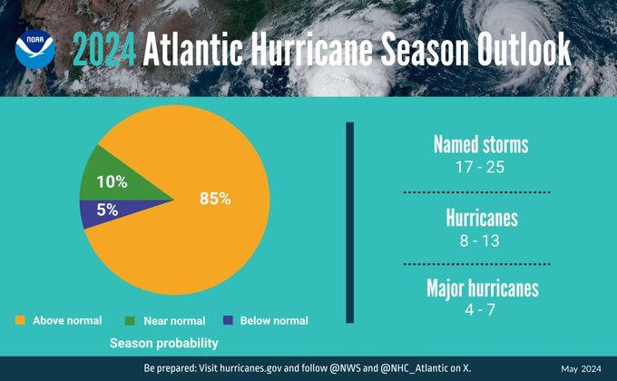
This is the highest storm prediction NOAA has ever issued for their May outlook.
"It only takes one storm to devastate a community," according to NOAA Administrator, Dr. Richard Spinrad, during the press briefing. He also said this hurricane season, "...is looking to be an extraordinary one."
WATCH THE NOAA NEWS CONFERENCE BELOW:
In a news release, NOAA, explained how they'll be working to keep you informed this hurricane season.
Enhanced communications in store for 2024 season
NOAA will implement improvements to its forecast communications, decision support and storm recovery efforts this season. These include:
- The National Hurricane Center (NHC) will expand its offering of Spanish language text products to include all Public Advisories, the Tropical Cyclone Discussion, the Tropical Cyclone Update and Key Messages in the Atlantic basin.
- Beginning on or around August 15, NHC will start to issue an experimental version of the forecast cone graphic that includes a depiction of inland tropical storm and hurricane watches and warnings in effect for the continental U.S. Research indicates that the addition of inland watches and warnings to the cone graphic will help communicate inland hazards during tropical cyclone events without overcomplicating the current version of the graphic.
- This season, the NHC will be able to issue U.S. tropical cyclone watches and warnings with regular or intermediate public advisories. This means that if updates to watches and warnings for storm surge or winds are needed, the NHC will be able to notify the public in an intermediate advisory instead of having to wait for the next full advisory issued every 6 hours.
New tools for hurricane analysis and forecasting this year
- Two new forecast models developed by NOAA researchers will go into operation this season: The Modular Ocean Model or MOM6 will be added to the Hurricane Analysis and Forecast System to improve the representation of the key role the ocean plays in driving hurricane intensity. Another model, SDCON, will predict the probability of tropical cyclone rapid intensification.
- NOAA’s new generation of Flood Inundation Mapping, made possible through President Biden’s Bipartisan Infrastructure Law, will provide information to emergency and water managers to prepare and respond to potential flooding and help local officials better prepare to protect people and infrastructure.
- NOAA’s Weather Prediction Center, in partnership with the NHC, will issue an experimental rainfall graphic for the Caribbean and Central America during the 2024 hurricane season. This graphic provides forecast rainfall totals associated with a tropical cyclone or disturbance for a specified time period.
System upgrades in operation
NOAA will upgrade its observing systems critical in understanding and forecasting hurricanes. These projects will provide more observations of the ocean and atmosphere in the Caribbean, the Gulf of Mexico, on the U.S. East Coast and in the tropical Atlantic.
- NOAA’s National Data Buoy Center recently upgraded many coastal weather buoys in the tropical western Atlantic and Caribbean to include time of occurrence and measurements of 1-minute wind speed and direction, 5-second peak wind gust and direction, and lowest 1-minute barometric pressure to support tropical cyclone forecasting.
- New this year, NOAA will gather additional observations using Directional Wave Spectra Drifters (DWSDs), deployed from the NOAA P-3 hurricane hunter aircraft and in the vicinity of Saildrones, uncrewed surface vehicles which will be deployed at the start of the hurricane season, providing one-minute data in real time. 11-12 Saildrones are planned for deployment in 2024.
- Starting in June, dozens of observational underwater gliders are planned to deploy in waters off the Caribbean, Gulf of Mexico and the eastern U.S. coast. Additionally, a new lightweight dropsonde called Streamsonde will be deployed into developing tropical storms, collecting multiple real-time observations to collect valuable wind data.
- The CHAOS (Coordinated Hurricane Atmosphere-Ocean Sampling) research experiment aims to improve the understanding of air-sea interactions, providing sustained monitoring of key ocean features.
About NOAA seasonal outlooks
NOAA’s outlook is for overall seasonal activity and is not a landfall forecast. In addition to the Atlantic seasonal outlook, NOAA also issues seasonal hurricane outlooks for the eastern Pacific, central Pacific and western north Pacific hurricane basins.
NOAA’s Climate Prediction Center will update the 2024 Atlantic seasonal outlook in early August, prior to the historical peak of the season.
