


Tropical Storm Ian overcame a dose of dry air late Sunday night in its effort to grow into a hurricane that will menace the Florida west coast this week.
Ian's center was located about 150 miles south of Grand Cayman, or about 400 miles from the western tip of Cuba.
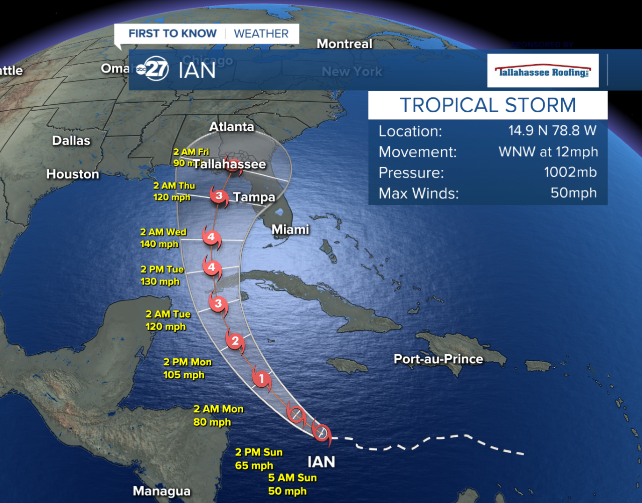
Ian was moving northwest at 13 mph, with highest wind speeds of 65 mph.
In the Lower Florida Keys and along the southwest Florida coast, a set of tropical storm watches is now in effect, as tropical storm conditions can occur within 48 hours there.
The intensification trends are essentially unchanged, as the very warm waters in the northwestern Caribbean and southeastern Gulf will be fuel to the circulation of the expected hurricane. Peak strength of Category 4 130-mph winds are noted in the forecast as it moves north, west of Key West, later Monday and Tuesday.
Trends favor a gradual turn to the north-northeast over the eastern Gulf. As it parallels near the peninsula, dry air and stronger upper winds in the northern Gulf are factored into a weakening trend for Ian. An eventual landfall of the storm's eye is possible anywhere from Fort Myers to Navarre Beach in the Panhandle.
Even with a possible weakening trend with Ian by Thursday and Friday, the Big Bend region will likely encounter times of heavy rain and squally conditions, with tropical storm sustained winds and wind gusts across a broad swath of the region. Coastal and offshore areas will have very rough surf and chances for storm surge-induced higher water levels and coastal flooding and beach erosion.
Rainfall amounts, generally speaking, can range from 2" to 6" or more, though eventual, specific storm effects for the Big Bend and southern Georgia have yet to be determined.
UPDATE: 11 AM 9/25
According to the Sunday 11 AM update issued by the National Hurricane Center, there is minimal change to the projected long term track of Tropical Storm Ian.
Current local impacts we're monitoring are potential tropical storm force winds, heavy rain and coastal storm surges beginning as early as Wednesday.
Cuba has been upgraded to a Hurricane Warning for the provinces of Isla De Juventud, Pinar Del Rio and Artemisa. A Hurricane Warning is also in effect for Grand Cayman.
————————————————————————————————————————————————————————————————————————————
UPDATE: 5 AM 9/25
Tropical Storm Ian show signs of steady strengthening later today and is expected to become a Category 1 hurricane early Monday. Max winds are currently at 50 mph.
Ian is forecast to reach Category 3 status as it shifts over the western part of Cuba early Tuesday morning. The risk of significant storm surge and flooding impacts have increased for this area.
The storm is expected to approach the Florida Peninsula by Wednesday as a Category 3. Based on the latest forecast track, regions of the Northeast Gulf could potentially see the increased likelihood of hurricane impacts like heavy rainfall and strong winds by Wednesday - Friday AM.
It is important to keep in mind that there is still a level of uncertainty with the long term timing of Ian's track, so please keep an eye on the latest updates.
——————————————————————————————————————————————————————————————————————————————-
UPDATE: 11 PM 9/24

Tropical Storm Ian is forecasted to become a hurricane on Sunday as of the 11 PM update. This is a day earlier than previously forecasted.
The track of Ian has not changed much with landfall still forecasted in the Big Bend area by Thursday night.
We do have some changes to strength as the storm approaches land though.
Still expected to be a major Category 3 storm on Monday night, Ian will track up to the west of Cuba as a major Category 4 hurricane Tuesday morning.
After maintaining a Category 4 strength through Wednesday night, the storm looks to weaken significantly as it approaches land and is expected to approach the Big Bend area as a Category 1 storm Thursday night.
As of this new advisory, we can expect tropical wind and rain starting early Thursday morning with higher storm surge likely through late-week.
The cone of uncertainty is very large still with this latest update.
We will still need to be prepared as this track changes every advisory.
—————————————————————————————————————————————————————————————————————————
Update: 5 PM 9/24

As Tropical Storm Ian moves out of shear (upper level wind) formation will become rapidly intensifying for the late weekend. As of the 5 PM update on Saturday, the Tropical Storm has more of an oval eye which means tracks are still varying without strict model agreement.
As this eye becomes more uniform and the storm intensifies, we will have a much better agreement on where this storm continues to head through the next several days.
As of the latest update, a new westerly path has taken shape.
This means the Big Bend area is now more likely to see tropical storm winds and rain as this storm approaches Wednesday and Thursday.
As the storm progresses into the Gulf, the forecast now calls for intensification to a Category 4 hurricane before becoming a Category 2 hurricane before making landfall somewhere along the Gulf shores of Florida.
————————————————————————————————————————————————————————————
Update: 11 AM 9/24
According to the latest NHC advisory that was issued at 11 AM Saturday, Tropical Storm Ian continues to push north with further strengthening expected by the end of the weekend.
More development continues this weekend as Tropical Storm Ian gains strength over the Caribbean and southern Gulf.
Forecasts still hold that the tropical storm will increase in strength over the weekend to become a hurricane early next week.
Forecast tracks have not changed much from early tracks, but our area is still within the cone of uncertainty. There was a slight wobble of the storm to the west this morning. This leads to an increase in chances of rain and wind from outer bands in our area Thursday.
It is worth repeating- the track will likely change over the next several days, so it’s best to be prepared either way. We still have a few weeks to go in hurricane season.
UPDATE: 5 AM 9/24-

As Saturday's sunrise approaches, Tropical Storm Ian continues to show signs of strengthening.
Tropical Storm winds have now peaked at 45 MPH.
This storm continues to move out of areas of high shear (upper level winds) and into warmer water.
As that happens, Ian is still forecast to become a hurricane by Monday early morning.
The cone of uncertainty remains large as uncertainty remains high as this storm moves into the Gulf over the next few days.
We are keeping an eye on the track of this storm as we head into late-weekend as things look to strengthen over the next 48 hours.
Without much of a change in trajectory, we can still expect some areas of the Big Bend (especially southeast Big Bend) to see bands of rain at times and gusty tropical wind for Wednesday and Thursday.
This path may change with time, so it is always good to be prepared before this storm approaches.
———————————————————————————————————————————————————————————————————————
The Caribbean disturbance we've been tracking since early this week has grown enough organization to be called Tropical Storm Ian.
Late Friday night, Ian was located less than 400 miles east-southeast of Kingston, Jamaica, moving to the west-northwest at 12 mph.
The tropical storm has peak wind speeds of 40 mph.
Ian is projected to maintain its strength, then gradually intensify over the central Caribbean as it moves west to west-northwest. Further intensification into a hurricane is probable once Ian reaches the very warm waters of the northwestern Caribbean early next week.
The storm is triggering a Tropical Storm Watch for Jamaica and a Hurricane Watch for the Cayman Islands, where storm-related conditions are expected to happen in those locations within 48 hours.
A front entering the Florida/Georgia line region next Monday or Tuesday will play a role in the system's eventual turn to the north and northeast, one of the primary factors behind the current shape of the forecast cone.
The forecast cone considers a wider margin or error in the day four to five forecast period, meaning the center of the cyclone can be located anywhere within that cone. The cone does cover Apalachee Bay, most Big Bend counties, and parts of our Suwannee River and Alapaha River southern Georgia areas.
Obviously this track will deviate as there are still many variables to consider impacting this storms trajectory over the next several days.
Keep in mind some of our viewing area is still in that 'cone of uncertainty', so while it is best not to panic, being prepared for tropical storms and hurricanes is always a good idea this time of year.
If this storm stays on its current path (even though unlikely), southern Big Bend and Suwannee River counties will be able to receive heavy rain and gusty wind at times around midweek and beyond. Precise local storm effects are challenging to pinpoint at this phase, and can range dramatically from sunshine and dry air in the western half of the region to tropical storm conditions farther east. The forecast trends over the weekend will give better clues for specific storm expectations for the Big Bend and southern Georgia.
Rip currents will also be strong starting next week for sections of the Big Bend coastlines, with rougher surf offshore in Apalachee Bay.
