


Update
Sept. 28th, 5:00 p.m.:
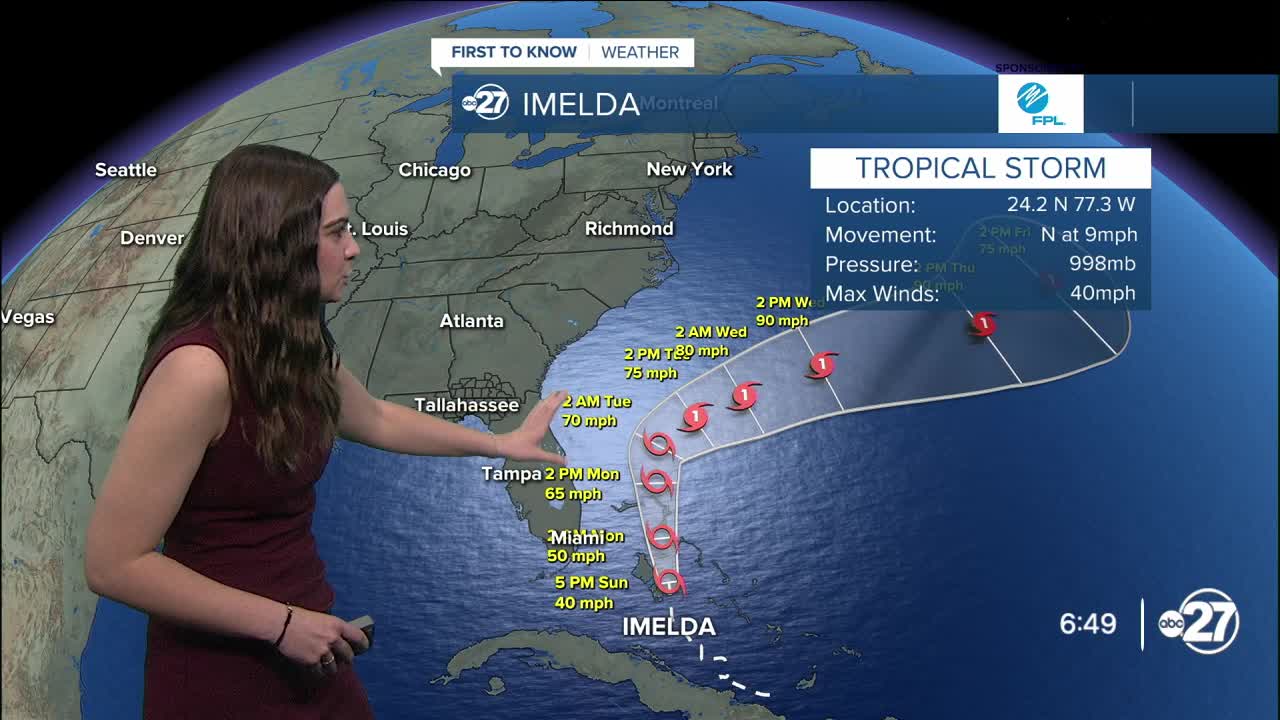
Once Potential Tropical cyclone Nine and Tropical Depression Nine is now Tropical Storm Imelda. The system is located over the Bahamas with maximum sustained winds of 45 mph and is moving north at 9 mph.
Imelda is expected to strengthen to a category 1 hurricane shortly after making a sharp turn eastward; avoiding direct landfall in the U.S.. Tropical Storm watches and warnings have been canceled for the east coast of Florida.
A mix of the front over the eastern U.S. and Hurricane Humberto to the east of Imelda is going to help push and pull Imelda out into the Atlantic. Large waves are expected along the east coast, especially for Florida, and (if Imelda hugs the western part of the cone) heavy rain is still expected for the coast of Georgia and the Carolinas.
Speaking of Hurricane Humberto, now a category 4 storm with maximum sustained winds of 145 mph, the system will stay out in the open water.
Sept. 26th, 5:00 p.m.:
As of 5 p.m., Invest 94L is now Potential Tropical Cyclone Nine. The first cone is showing a north-northwesterly track until it reaches the Carolina area, that is where the uncertainty lies.
It is, however, expected to strengthen to a category 1 hurricane by Monday afternoon.
Humberto has rapidly intensified to a category 3 storm with maximum sustained winds of 115 mph.
Moving slowly to the northwest at 5 mph, Humberto is expected to continue to strengthen but stay out in the Atlantic.
Original
We are continuing to closely monitor both Hurricane Humberto and Invest 94L.
Hurricane Humberto is continuing to go through rapid intensification as of the afternoon Friday.
Currently a category 1 storm, Humberto is expected to continue to track northwest before eventually turning to the north and northeast Tuesday into Wednesday. Strengthening is also expected to continue, becoming a category 4 storm by Saturday night.
Humberto poses no threat the the U.S. at this time.
Invest 94L is trying to get better organized, but there are no new major updates as of right now. The system still has a 90% chance of development over the next 48 hours and a the next 7 days.
Situated just north of eastern Cuba, the system will continue to move in a northerly direction and strengthen as it does so.
With many variables influencing the track of 94L, the exact track is uncertain at this time.
The cold front moving through the Big Bend and south Georgia Friday is expected to stall just to our east. This could potentially pull 94L towards the east coast with a landfall near the Carolina's, which is what a majority of the spaghetti models are hinting at.
However, if the timing is right and Humberto comes close enough to 94L, Humberto could pull 94L out to sea, avoiding any direct landfall.
At this time, it is way too early to know the exact track and strength of 94L, but it will not be having any direct impacts to our local area.
We will keep you updated as they occur both on air and online.
Want to see more local news? Visit the WTXL ABC 27 Website.
Stay in touch with us anywhere, anytime.
