


Update
July 16, 8 a.m.;
The system hugged northern tracks overnight and is currently situated over more land than water, preventing strengthening.
Isolated showers and storms are moving onshore and will become scattered through the afternoon. The system is also providing lots of cloud cover and humidity across the area.
As it tracks westward, we will continue to see a southerly wind flow, pushing moisture into the area. Local impacts remain at 2-3" of rainfall for coastal neighborhoods and 20-25mph wind gusts throughout the day Wednesday.
Chances remain low for development of this system, but we will continue to monitor it.
07/15/2025, 6:30 pm:
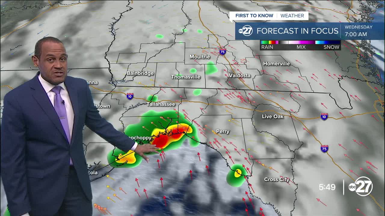
Rain connected to the tropical disturbance — inland Tuesday evening in the north-central Florida peninsula — will have a greater effect on coastal locations Wednesday morning. Its circulation has driven downpours in the US 19 corridor or Taylor County as northeast winds met the sea breeze. The low itself will move over Apalachee Bay Wednesday morning, flinging periods of rain across the coastal counties before sunrise. A southeast wind pattern triggered by the tropical low will drive scattered rain and thunderstorms across the central and western Big Bend Wednesday morning and afternoon, which will move into southwestern Georgia in the afternoon. These areas of rain will be locally heavy, but a widespread swath of heavy rain or severe storms is not anticipated to occur. Local breezes will be around 5 to 15 mph, with gusts near 25mph along the coast and offshore.
No tropical-related advisories or watches are expected, as the disturbance will not quickly strengthen during its closest approach to our area Wednesday.
While the chance is very low, we will monitor for a possible waterspout that may approach the coastline under the right conditions.
July 15, 8 a.m.;
A 40% chance of development remains in place as Invest 93L begins to make its way westward through Florida.
Local impacts remain minimal with this system as localized downpours and gusty winds are possible.
Wind gusts of 20-25mph are expected Wednesday afternoon, mainly for coastal neighborhoods as the wind will be shifting to south/southeasterly.
The system remains disorganized, but is expected to become more organized once it is over the warm waters of the Gulf.
July 15, 2 a.m.;
The National Hurricane Center is now giving Invest 93L a 40% chance of development over the next 48 hours and 7 days.
The cluster of thunderstorms is still located off of the east coast of Florida, but expected to move west across the state Tuesday.
Development continues to be possible once the system enters the Gulf, however, local threats remain low.
The most we are expected to see at this time is heavy rainfall and gusty winds.
Original
The zone of disorganized tropical moisture is swirling a few dozen miles off the central Florida east coast late Monday night. There's not much expectation in the next day or two for it to strengthen with low pressure, but the concentrated moisture is expected to remain intact.
Forecast trends suggest it will move west, over the through the northern half of the Florida peninsula, Tuesday and Wednesday morning, reaching the eastern Gulf waters at midweek.
This path would bring times of downpours to the peninsula of Florida Tuesday. It will also influence an eventual shift in local winds, becoming southeast late Tuesday and Wednesday, supporting a pickup in the amount of scattered showers and storms for the Big Bend and southernmost Georgia Wednesday and Thursday.
The peak local effects from this system — unlikely to be anything strong or significant — will be encountered in the form of periods of rain and modest wind gusts over marine areas that will be below tropical storm level winds. About one to two inches of rain are possible. Rain action is not expected to be continuous Wednesday and Thursday, but more intermittent and briefly heavy. Severe weather chances will be low.
Nearby high pressure will guide the system steadily to the west beyond Wednesday. As the disturbance moves over the warm northern Gulf waters, amid a light upper-level wind pattern, some organization is expected to occur. When this happens, the system will be well west of our region, focused more on the central Gulf Coast.
If it turns into a tropical storm later this week, it will be named Dexter. Broader effects from the system are possible in the lower Mississippi River region and sections of Louisiana.
Want to see more local news? Visit the WTXL ABC 27 Website.
Stay in touch with us anywhere, anytime.
