
According to the latest advisory from the National Weather Service, Nestor has lost it's tropical characteristics.
THE LATEST ADVISORY:
The post-tropical cyclone is moving toward the east-northeast near 9 mph (15 km/h), and this motion is expected to continue this morning and early afternoon, followed by a motion toward the northeast by tonight and early Sunday.
Satellite imagery, NOAA Doppler weather radar data, and surface observations indicate that the center of Tropical Storm Nestor has redeveloped farther west.
Download our apps | ABC 27 Mobile App for iOs | ABC Mobile App for Android | Storm Shield for iOS | Storm Shield for Android
On the forecast track, Post-Tropical Cyclone Nestor will move inland over the Florida Panhandle this afternoon, and will then move across portions of the southeastern United States later tonight and Sunday. The cyclone is expected to move offshore of the coast of North Carolina into the western Atlantic by late Sunday.
Maximum sustained winds are near 50 mph (85 km/h) with higher gusts.
No change in strength is anticipated before Nestor reaches the coast, but is forecast to weaken after it moves inland.
BIGGEST THREATS:
A National Ocean Service tide gauge at Apalachicola, Florida, recently measured a water level of 3.2 ft above Mean Higher High Water.
The tornado threat is elevated across the Florida Panhandle and Big Bend as well as South Georgia and Alabama counties where isolated tornadoes are possible. Counties east of the storm will face the greatest risk for tornado activity.
Tropical-storm-force winds extend outward up to 185 miles (260 km) mainly to the east of the center. The winds will spread inland. The strongest winds will be felt along the immediate coast leading to coastal flooding, beach erosion and very strong and frequent rip currents.
Downed trees, power outages, building damage and localized flooding are still possible with this storm.
WATCHES & WARNINGS:
Watches and warnings have been issued:
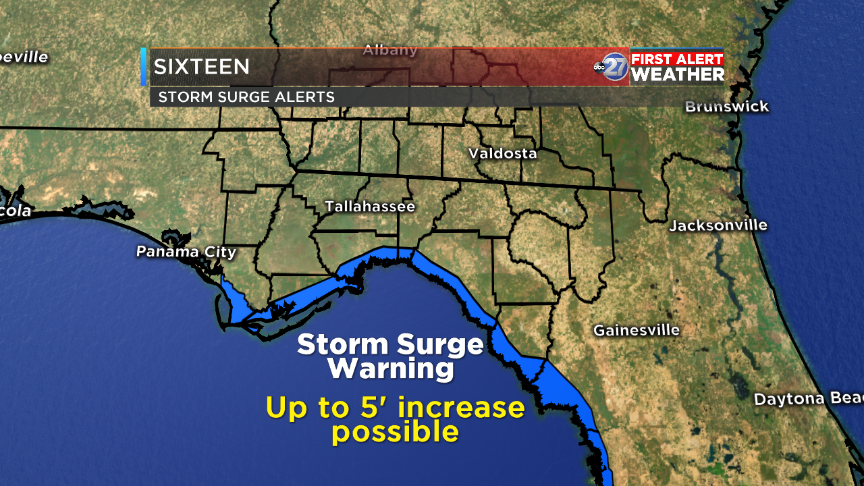
- Tropical Storm Warning from Indian Pass to Yankeetown, Florida
- Storm Surge Warning from Indian Pass, FL to Clearwater Beach, FL
- Storm Surge Warning and Tropical Storm Warning in effect for Coastal Dixie, Coastal Franklin, Coastal Gulf, Coastal Jefferson and Coastal Wakulla
Regardless of the exact track and intensity of the system, these winds will cover a large area, especially east of the center, and begin well in advance of the arrival of the center.
As always, the First Alert Weather team will keep you updated on the latest developments this hurricane season.
Below is a list of Tallahassee radio stations that provide WTXL's weather updates:
- 103.1 The Wolf
- Tally 99.9
- HOT 104.9
- Kool Oldies 106.1
Here's a list of links to report power outages in your area:
- City of Tallahassee utilities customers can report power outages here.
- Talquin Electric Cooperative customers can report power outages here.
- Duke Energy customers can report power outages here.
- Colquitt Electric Membership customers can report power outages here.
- Suwannee Valley Electric Cooperative customers can report power outages here.
- Tri-County Electric Cooperative customers can report power outages here.
- Georgia Power customers can report power outages here.
- Mitchell Electric Membership Corporation customers can report power outages here.
- Municipal Electric Authority of Georgia customers can report power outages here.
- Thomasville Utilities customers can report power outages here.
- City of Moultrie Utilities customers can report power outages here.
